The Beast from the East is slain

Paul Hudson
The cold easterly which a large majority of computer models were predicting to develop this week has failed to materialise, with a much more unsettled weather pattern expected to return from the Atlantic during tomorrow.
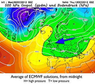
Last week, 80% of the ECMWF model solutions wanted an easterly 'blocking' weather pattern, with the average of those solutions shown below.
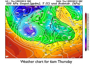
Compare that with the atmosphere this morning (according to the GFS model), below.
Crucially the centre of gravity of the large area of high pressure, which should have been closer to Scandinavia, is further northeast than predicted.
This positional error means that Atlantic weather systems will now be able to make further progress eastwards across the UK.
It illustrates very well just how difficult it is sometimes to forecast general weather conditions a week ahead, even when there's high model confidence.
So after a temporary cold and dry spell, it now seems likely that the rest of December will be very unsettled, with showers or longer spells of rain, some of which will be heavy, with only very brief incursions of colder air.
Follow me on twitter @Hudsonweather