First cold snap of the season

Paul Hudson
After a relentlessly gloomy week, much clearer but colder air is on its way from the Arctic in the next 12 hours, giving us our first cold snap of the season, albeit a short lived one.
Some of us, mainly in eastern parts of the region will see showers, and the air will be cold enough for some of these to have a wintry flavour - with hail, sleet and some snow.
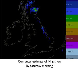
By Friday night, the North York moors and Wolds could have a slight covering of snow, as you can see on the figure below, although this will melt very quickly on Saturday.
Further west, skies will be mainly sunny on Friday and Saturday, with excellent visibility for those who enjoy a bracing walk in the Pennines, but a widespread frost expected at night.
It's perfectly normal to get a cold snap at this time of the year, and it will prove to be temporary, as less cold Atlantic air moves back in on Sunday, bringing cloud and some rain.
But it comes after what has been quite an exceptional few weeks of below average temperatures.
According to climatologist Philip Eden, the period from mid-September to mid-October was the coldest such period since 1974, and in the last century only 1952 and 1905 was colder.
As for next week, it's a familiar story, with low pressure set to dominate, leading to changeable and unsettled weather across many parts of Yorkshire and Lincolnshire, with temperatures at best close to average.
But with winds from the west, there will be some dry, bright weather at times, with eastern areas most favoured.
Follow me on twitter @Hudsonweather