Quiet spell of autumn weather on the way

Paul Hudson
After what has seemed like a relentless period of unsettled weather stretching back to the end of March, it's nice to be able to report that a quieter spell of weather seems likely next week - although talk of an 'Indian Summer', for our region at least, is a little far-fetched.
Friday and Saturday look generally dry, although there will be some fog to contend with in the mornings.
The change will come courtesy of a warm front which will bring some rain and drizzle from the southeast later on Sunday.
Thereafter, the good news is that a ridge of high pressure will dominate our weather, meaning much drier weather on the whole next week.
And at first glance, it is easy to get carried away with the fact that the air which is on its way from the continent is warm.
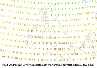
But, unfortunately for us, it has to travel across the North Sea.
And as it does so, the warmer air coming into contact with the colder North Sea is likely to generate extensive low cloud at times.
In these situations it is possible to get quite high temperatures - for example where there is shelter from the prevailing south-easterly wind, like west of the Pennines, or areas where the warm air only has to travel across a short sea track, like southern parts of the UK.
But for our part of the world, skies are likely to be predominantly cloudy - although with light winds and generally dry conditions (apart from drizzle which can form in extensive low cloud), it should be an improvement compared with what we've been used to.
And let's hang on to the possibility that even here cloud breaks can occur in this set up, leading to at least the chance of some warm sunshine at times.
Follow me on twitter @Hudsonweather